
New Study: The Most Dangerous Intersections for Pedestrians in San Diego
Pedestrian collisions are on the rise across the county and San Diego County is no exception. From 2010-2016, there were 7,589 pedestrian involved collisions in San Diego which left more than 430 dead and 7,700 injured. Indeed, San Diego is a dangerous place for pedestrians. But what areas put pedestrians at the highest risk of being hit by a car?
[1p21video src=”/wp-content/uploads/2017/11/sandieg-pedestrians.mp4″ width=”735″ id=”gif_replace_center”]
To find out, our San Diego car accident lawyers collaborated with local data analysis and visualization firm 1point21 Interactive. We analyzed over 160,000 collision records and identified intersections where at least five pedestrian involved crashes occurred. These dangerous intersections – 218 in total – accounted for 1,428 crashes, 1,488 total injuries and 42 fatalities.
In other words, nearly 20 percent of all pedestrian collisions in San Diego County occurred at only 218 intersections.
The Most Dangerous Intersections for Pedestrians: Top 50
This list includes all locations where at least five pedestrian collisions occurred during the study period. The Pedestrian Danger Index (PDI) takes crash volume and injury severity into account for each intersection.
| Rank | Road 1 | Road 2 | Crashes | Fatals | PDI |
| 1 | University Av | 1St Av | 20 | 0 | 63 |
| 2 | Valley Pkwy | Midway Av | 13 | 2 | 62 |
| 3 | Linda Vista Rd | Ulric | 13 | 1 | 56 |
| 4 | 4Th Av | C St | 9 | 2 | 53 |
| 5 | Federal Bl | Euclid Av | 11 | 0 | 49 |
| 6 | El Cajon Bl | Altadena Av | 9 | 2 | 47 |
| 7 | Camino Del Rio | Sports Arena Bl | 8 | 1 | 44 |
| 8 | University Av | Estrella Av | 5 | 1 | 43 |
| 9 | University Av | 44Th St | 11 | 0 | 43 |
| 10 | University Av | Fairmount Av | 12 | 0 | 41 |
| 11 | Garnet Av | Mission Bl | 11 | 0 | 40 |
| 12 | Broadway Av | 3Rd Av | 11 | 1 | 39 |
| 13 | Broadway | I St | 9 | 0 | 39 |
| 14 | El Cajon Bl | Boulevard Pl | 10 | 0 | 39 |
| 15 | Quintard St | 3Rd Av | 8 | 1 | 38 |
| 16 | Garnet Av | Everts St | 9 | 0 | 38 |
| 17 | Rosecrans St | Midway Dr | 13 | 0 | 38 |
| 18 | East 18Th St | Highland Av | 9 | 0 | 37 |
| 19 | 11Th St | Broadway | 9 | 0 | 36 |
| 20 | North Harbor Dr | Rosecrans St | 9 | 0 | 36 |
| 21 | Midway Dr | West Point Loma Bl | 8 | 1 | 35 |
| 22 | Broadway | G St | 8 | 0 | 35 |
| 23 | 5Th Av | G St | 9 | 0 | 35 |
| 24 | Saturn Bl | Palm Av | 11 | 0 | 34 |
| 25 | Garnet Av | Dawes St | 9 | 0 | 34 |
| 26 | Palomar St | Broadway | 14 | 0 | 34 |
| 27 | Quince St | Mission Av | 7 | 1 | 33 |
| 28 | El Cajon Bl | Winona Av | 8 | 1 | 33 |
| 29 | Paradise Valley Rd | Deep Dell Rd | 8 | 0 | 33 |
| 30 | University Av | College Av | 8 | 0 | 33 |
| 31 | East Vista Wy | Arcadia Av | 6 | 1 | 32 |
| 32 | Broadway | Oxford St | 9 | 1 | 32 |
| 33 | Mira Mesa Bl | Marbury Av | 6 | 1 | 32 |
| 34 | El Cajon Bl | 50Th St | 7 | 0 | 32 |
| 35 | Clairemont Mesa Bl | Diane Av | 8 | 0 | 32 |
| 36 | S 3Rd St | Washington | 10 | 0 | 32 |
| 37 | Mission Bl | Hornblend St | 7 | 0 | 32 |
| 38 | University Av | Menlo Av | 9 | 0 | 32 |
| 39 | Kurtz St | Rosecrans St | 5 | 1 | 31 |
| 40 | Harbor Dr | Park Bl | 6 | 1 | 31 |
| 41 | Grand Av | Lamont St | 6 | 1 | 31 |
| 42 | East Main St | Jamacha | 7 | 1 | 31 |
| 43 | El Cajon Bl | 36Th St | 6 | 0 | 31 |
| 44 | 30Th St | Market | 8 | 0 | 31 |
| 45 | 3Rd Av | K St | 9 | 0 | 31 |
| 46 | North Santa Fe Av | Indian Rock Rd | 10 | 0 | 31 |
| 47 | Marshall | Palm | 10 | 0 | 31 |
| 48 | La Jolla Village Dr | Lebon Dr | 5 | 1 | 30 |
| 49 | Fletcher Pkwy | Johnson | 6 | 1 | 30 |
| 50 | Front St | Ash St | 7 | 0 | 30 |
Notable intersections on the list include:
- #1: University Avenue/1st Avenue, Hillcrest. The most dangerous intersection in San Diego, infamous in the Hillcrest neighborhood for its high congestion, dim lighting, and poorly maintained crosswalks – all major contributing factors to its lack of safety.
- #2: Valley Parkway/Midway Drive, Escondido. Ranked second, this intersection in North County seems like an outlier. Although it’s in close proximity of many schools, no immediate reason jumps out – and with 2 fatalities, it may be an intersection worth investigating.
- #3: Linda Vista Road/Ulric Street, Linda Vista. Serving as a major local corridor from Kearny Mesa to Mission Valley, Linda Vista Road is one of the busiest streets in San Diego, with average traffic topping out at 28,000 vehicles daily at this specific intersection. Heavy wear-and-tear on the roads, poorly maintained crosswalks, and inattentive vehicles are major contributors to the danger at this intersection.
- #4: 4th Avenue/C Street, Chula Vista. This intersection in Chula Vista borders a nearby park and a DMV location, which may add to the lack of safety. With wide roads, speeding vehicles, and long crosswalks, this intersection is particularly dangerous for pedestrians, recording the same amount of fatalities as our #2 intersection, Valley Pkwy & Midway Drive, on 30 percent fewer crashes.
- #5: Federal Blvd/Euclid Avenue, Oak Park. One block north of the Highway-94 offramp, this intersection had the highest incidences of severe injuries – five of eight total injuries were serious. Both streets have high amounts of traffic; Euclid in particular causes heavy congestion due to the merge of two equally busy major streets – Euclid Ave and 54th Street – to the north.
- #7 & #17: Camino Del Rio/Sports Arena Blvd & Rosecrans Street/Midway Drive, Point Loma. These intersections are one block apart in a heavily congested portion of Point Loma. High amounts of traffic, high instances of tourists heading to the beach, and confusing roadways make these two intersections a disaster for pedestrians.
A Look at University Avenue
Dangerous intersections along University Avenue are highly prevalent in our findings. Four of the top 10 occur on University Avenue, more than 10 percent of intersections on the list involve the street. Although this is a cause for concern, much of this can be attributed to the significance of University as a major east-west corridor, stretching as far west as Mission Hills and as far east as La Mesa. In fact, the roadway is 9.79 miles long – the third-longest road in the county.
Interactive Map: Pedestrian Collisions and High-Risk Areas
Because major roads in San Diego (such as University Avenue) can be fairly lengthy, this may skew the single street-level data towards those longer roads – focusing more on the distribution rather than the concentration of incidents. Thus, for further analysis, we grouped dangerous intersections within 250 feet of each other to create clusters with a high concentration of both overall incidents and dangerous intersections. We identified ten zones that San Diego pedestrians at much higher risk of collision – totaling 286 pedestrian collisions across 37 intersections, resulting in 287 total injuries and six fatalities.
High-Risk Pedestrian Zones in San Diego County
| Crashes | Intersections | Neighborhood/Region | Total Injuries | Total Fatals |
| 63 | 9 | Downtown – Horton Plaza | 65 | 2 |
| 38 | 6 | Hillcrest – 5th Avenue | 43 | 0 |
| 36 | 3 | Hillcrest – 1st Avenue | 37 | 0 |
| 29 | 4 | PB – Mission Blvd | 34 | 0 |
| 25 | 3 | PB – Garnet Avenue | 29 | 0 |
| 24 | 3 | El Cajon Blvd – Talmadge | 22 | 3 |
| 23 | 2 | University Ave – City Heights | 25 | 0 |
| 17 | 3 | Downtown – Civic Center | 17 | 0 |
| 16 | 2 | Downtown – East Village | 15 | 1 |
This interactive map shows all 4,784 intersections where at least one pedestrian collision. Larger circle sizes denote higher collision volume at that intersection. Clusters of dangerous intersections are highlighted in white. For a full screen interactive version of the map, click here.
These dangerous zones generally reside in five neighborhoods within San Diego County.
Downtown
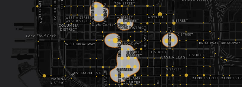
The Downtown area tipped the scales when it came to pedestrian collisions, with three distinct zones residing in the region.
The Horton Plaza Zone was in the top spot, amassing 63 total collisions across just nine intersections – and resulting in 65 injuries and two fatalities. The intersection at Broadway & 3rd Avenue – the 12th most dangerous intersection according to our data – takes the top spot, with 4th Avenue & Market St and 5th Avenue and G St trailing shortly behind.
The Civic Center Zone amassed 17 total collisions across 3 dangerous intersections, ranking 8th on our list of dangerous clusters. The intersection at Front St and Ash St accounts for roughly 40 percent of collisions in this cluster, with both seven crashes and injuries.
The East Village Zone compiled 16 total collisions in just two intersections, both along Broadway and on consecutive blocks, on 11th Avenue and Park Blvd. This is the 9th most dangerous zone in San Diego on arguably the busiest street in East Village.
The urban epicenter of the city, Downtown has a high incidence of pedestrian collisions for many reasons.
- High motorist traffic combined with high pedestrian traffic.
- The confusing orientation of alternating one-way streets.
- A surge in homeless population – 27 percent in the past year alone.
- A steady incline in residents – a surge of 97 percent since 2000.
Hillcrest
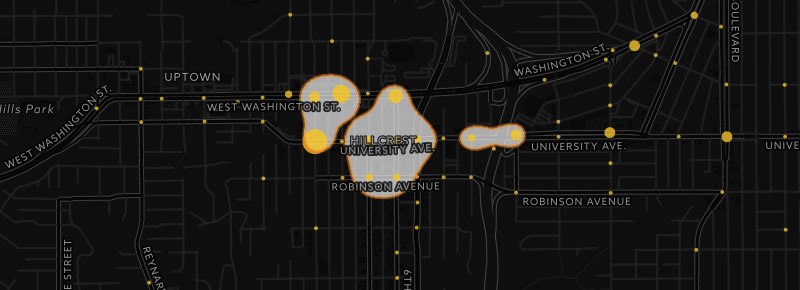
The bustling Hillcrest neighborhood is home to the 2nd and 3rd most dangerous zones in San Diego County.
The 5th Avenue Zone amassed 38 pedestrian collisions across 6 intersections, primarily centered around 5th Avenue. The intersection of 5th Avenue and Washington Street took the top spot, with 9 crashes and 11 injuries.
The 1st Avenue Zone accumulated just two fewer collisions than the 5th Avenue Zone, with half as many intersections. This can be primarily attributed to the intersection at University Avenue and 1st Avenue, the most dangerous intersection in San Diego according to our data. This intersection had 20 total crashes resulting in 21 injuries – more than half of all crashes in this cluster.
Hillcrest shares similar characteristics with Downtown that may lead to higher rates of pedestrian collisions. This includes:
- High motorist traffic combined with high pedestrian traffic – especially on weekends.
- An inconsistent pattern of one-way streets – 4th and 5th Avenue are one-way streets, yet all the other numbered streets in Hillcrest are two-way.
- A steady increase in homeless population – especially as Downtown encampments are shut down.
Additional attributes also factor into weakened pedestrian safety in Hillcrest.
- Cars are prone to speeding on certain roads – namely, Washington Street, where some vehicles can reach speeds as high as 50mph.
- Lack of lighting at night, especially on smaller roads. Although only 38 percent of pedestrian crashes in San Diego occur during the night, 66 percent of all fatal collisions happen at night. The intersection at University and 1st Ave is notorious for being one of the more dimly lit intersections in the area.
Pacific Beach
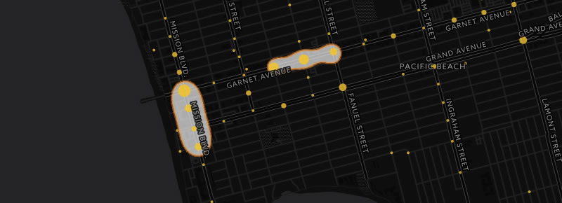
Coastal Pacific Beach is home to #4 and #5 of the most dangerous zones in San Diego:
The Mission Blvd Zone, comprised of four blocks of the major road, tallied 29 pedestrian collisions at 4 dangerous intersections, resulting in 34 total injuries. The intersection of Garnet Ave. and Mission, the epicenter of PB, had the most collisions, with 11 crashes and 13 injuries.
The three-block Garnet Avenue Zone, had 25 crashes over 3 intersections, totaling 29 injuries.
A bustling beach city by day and a raucous party city by night, Pacific Beach seems to be perpetually inundated with both pedestrians and wary motorists looking for a place to park. This combination of potentially intoxicated pedestrians and inattentive drivers may be a contributing factor to pedestrian collisions.
Also of note is that Pacific Beach is the jaywalking capital of San Diego. According to data from the San Diego Police Department, roughly one in five of the 4,284 jaywalking tickets issued in the city from 2011-2016 were written in Pacific Beach. In fact, the intersection at Garnet and Mission tops the list with 523 jaywalking tickets – more than 12 percent of all citations in the city.
City Heights/Talmadge
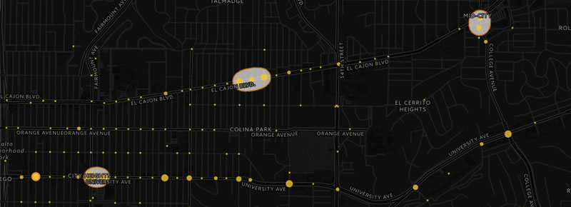
The neighborhoods of City Heights and Talmadge had their share of pedestrian collisions as well, with a few dangerous zones of pedestrian activity.
The three-block El Cajon Blvd Zone in Talmadge had 24 crashes across 3 intersections, resulting in 22 injuries and 3 fatalities – the highest amount of fatalities in any of the top ten zones. Residents have stated that poor crosswalk conditions, high vehicle speeds, and no streetlights in this area are major contributors to its safety.
The University Avenue Zone encompasses two blocks in City Heights, with 23 crashes occurring in 2 intersections, resulting in 25 injuries. Located in the City Heights Retail Village, this zone has a high amount of traffic and pedestrians.
East of rapidly gentrifying neighborhoods North Park and Normal Heights, City Heights and Talmadge are some of San Diego’s poorest and ethnically diverse neighborhoods. The neighborhoods have high population density and concentration of commercial businesses, resulting in more residents willing to travel on foot rather than by automobile.
But many of the streets in these areas aren’t optimized for pedestrians, with safety measures such as high-visibility crosswalks and traffic signals poorly maintained or altogether not present. Fortunately, a recent plan has been passed which looks to make University Avenue in City Heights a “complete street” with improvements such as wider sidewalks and painted bike lanes as a significant step forward in pedestrian and cyclist safety.
Oceanside

North County coastal city Oceanside contained the 10th most dangerous zone in San Diego, with a two-block stretch of Coast Highway that tallied 15 pedestrian collisions. The intersection at Coast Highway and Mission Avenue tallied 8 crashes, resulting in 9 injuries.
This intersection is arguably the busiest street in downtown Oceanside, with Mission Avenue being a major arterial highway that connects drivers on Interstate 5 to the scenic Oceanside Pier. Additionally, Coast Highway is another major traffic corridor which connects residents to southern cities such as Carlsbad and Encinitas.
Looking to Zero Deaths with The Vision Zero Program
In an effort to bolster pedestrian safety, San Diego proposed their version of the Vision Zero initiative in 2015. First implemented in Sweden in 1990, the pedestrian safety mandate aims for the ultimate goal of zero pedestrian deaths by a specified time frame. In San Diego’s case, that goal is zero deaths by the year 2025, with a special focus on eight trouble corridors in the city:
- Fifth Avenue
- Broadway
- El Cajon Boulevard
- Euclid Avenue
- Garnet Avenue
- Imperial Avenue
- Market Street
- University Avenue
The city plans on implementing improvements and changes to various trouble intersections throughout the county – their 2018 projects are highlighted in this interactive map. These improvements would theoretically include things as minor as repainting crosswalks, to major changes such as installing traffic lights and signals and converting stop sign intersections to roundabouts.
Unfortunately, the city of San Diego seems to be encountering the same hurdles other cities (such as San Francisco) have experienced with Vision Zero: it doesn’t seem to fully embrace the concept behind Vision Zero.
The inaugural Vision Zero initiative was a rousing success in Sweden because it pushed people to make a drastic change in their thought processes in order to preserve pedestrian lives. This means taking on major projects that introduce sweeping changes – not half-measures meant to compromise with the status quo.
In San Diego, state officials are currently initiating changes that serve as a half-measure to pedestrian safety – or improvements which are a compromise for the norm. Drastic proposals – such as removing parking spaces to make way for wider sidewalks and dedicated bike lanes – are summarily shot down as they prioritize the safety of pedestrians over the convenience of drivers.
As pedestrian deaths rise, it may be worthwhile to seriously reconsider our priorities when it comes to traffic, drivers, and pedestrians.